
Overview
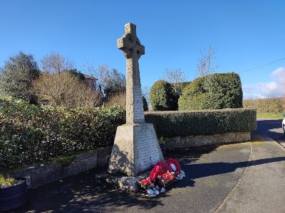
This month’s walk starts at the War Memorial (1) in Bwlchgywn, takes you to the charming little village of Ffrith and then up an old packhorse trail back to Bwlchgywn.
There are many fine views of Ffrith Valley along the route. You also pass through Black Wood and Nant Wood on its descent to the former Romano-British settlement at Ffrith. Many areas of scenic beauty make it a walk for all seasons.
Bwlchgwyn War Memorial (grid ref SJ263536; postcode LL11 5YQ; what3words: loved.enveloped.ranges) is in the village of Bwlchgwyn on the A525 between Wrexham and Ruthin. It is also known as the Aircrew LS766 Memorial.
There is ample car parking space by the memorial. You can take a bus to Bwlchgwyn from Monday to Saturday: head uphill on the main road to the walk starting point. Bus information is available on 01978 266 166 or at arrivabus.co.uk/wales/bus-travel-in-wrexham.
Ordnance Survey Explorer map 256 covers the area.
The route is not suitable for wheelchairs, buggies or small children. The ground is very boggy in some places, especially towards the end. Please wear decent boots and be prepared to climb over uprooted trees!
You may have to lift dogs over stiles at some points. There are several fields with sheep along the way.
Disclaimer
We keep to public footpaths as indicated on OS maps wherever possible.
You must read, understand and accept our disclaimer before attempting any of our walks.
Directions
Go down Glascoed Road. After about 250 yards, take the footpath to your left just after the house on the right called the Gors.
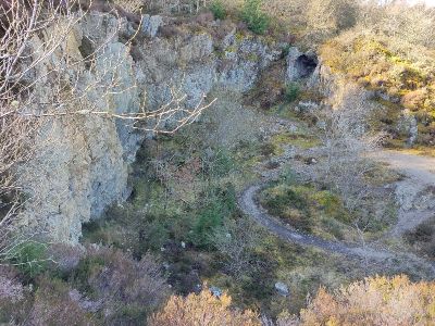
From here, there are views across the valley to Pen Llan y Gŵr mountain. Follow the path downhill, passing a quarry (2) on your left. Turn right onto the track running across you from left to right and head down to the road. Go straight across the lane onto the trail that runs to the right. Walk straight down through the coniferous woodland.
Go down some wooden steps built into the ground. Head straight over the track at the waymarker and continue downhill between mounds of cut pine branches. After a few minutes, bear left down to the lane before you and cross the bridge over the Nant y Ffrith.
Black Wood, Nant Wood
On the other side, turn left to see the building that was once part of Nant y Ffrith Hall Estate and is now a private residence. The estate featured stables and a coach house with an interesting cupola made of pitchpine and covered in lead.
The estate introduced trees and shrubs, including red oak and copper beech, which you can see growing among Forestry Commission conifers. The broadleaved trees help make Nant y Ffrith a suitable habitat for bats. Natterer’s, Daubenton’s and long-eared bats are some of the species that you can see at dusk.
Return to the bridge, but carry on straight up the track without crossing it this time. You’ll see a sign saying “Warning. Forest Operations”. Go through the gateway and carry straight on at the fork (follow the chevron-shaped arrow at the top of the wooden waymarker on your right). You will now find yourself on a track with steep wooded slopes above you to the left and below you to the right.
Walk along this path for about a mile. You will pass through first Black Wood and then Nant Wood. You’ll come to a metal kissing gate at the end of the track. Go through this, and you’ll see you’re on a narrow path flanked by metal fences with wooden posts. Follow the path as it bends round to the right of Nant Uchaf, an 18th-century smallholding, now modernised. Go through the two metal gates, taking care with the small step at the second one.
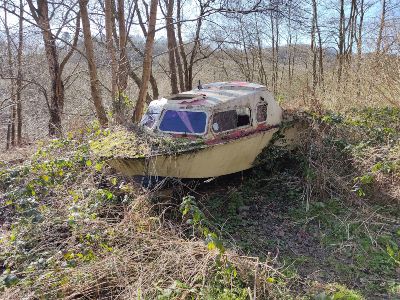
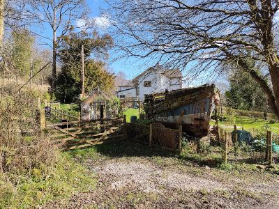
Two Old Boats
Turn right and head along the main track. You’ll pass an abandoned boat on your right (3), a cliff face, a derelict out-building on your left and, as you reach the property called “Nant Isa”, another boat (4)!
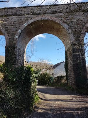
Carry on along the path. Hazel trees dominate the hedgerow as you make your way to the railway viaduct (5). Walk along the road into Ffrith.
After looking around the village, return to the viaduct. Take the left-hand path, go over the small bridge and turn right onto the path marked by the wooden post with the red and white reflectors.
Old Packhorse Trail
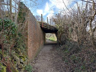
Your route now follows an old packhorse trail. Presently, you will pass under a mineral tramway bridge (6) and then pass what was Glascoed Hall. The original property dated back to the 17th century. Romans may have used the trail to carry lead from Minera to Ffrith.
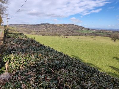
Turn left when you reach Glascoed Road again. Pass the prominent stand of black pine and, further on, Glascoed Hall Farm, which has fantastic views of Hope Mountain (7). Pass the two properties on your left, the first of which is Glascoed Lodge. Carry on along the road until you reach the left-hand hairpin after about four minutes.
Turn right at the green metal footpath sign and cross the tiny bridge. You may spot cobbles of coal in the water showing the location of outcropping seams.
Be careful here as you have to negotiate a fallen tree by climbing between the twin trunks. Once you’re through, take the two sets of wooden steps and hop over the stile. Turn left immediately between the two small trees and walk across the field, keeping the barbed wire fence immediately to your left.
Standing Stones
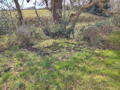
Pass through the metal gate and, keeping on approximately the same bearing (W), walk across the field using the metal gate in the corner to exit. Keep heading west and continue across the third field. You’ll pass a pair of standing stones (8) on your left before reaching a stile.
Turn right onto Cefn Road and turn left onto Glascoed Road after a quarter of a mile. Walk up Glascoed Road for about a mile until you arrive back at the war memorial.
Congratulations! You have finished the walk.
Additional Information
(1) Aerial photographs backed up by archaeological research have revealed a Stone Age settlement on top of Pen llan y gŵr. The footpath leading to the summit passes through the site, where you can still see stone hut circles.
(2) Thomas Fry, a Liverpool tea merchant built Nant y Ffrith Hall in 1850. The building was originally to be a hunting lodge, but Fry died shortly after its completion. Mr Peek, another tea merchant, turned it into a country residence, adding many fine features and extending the gardens. In 1865, it was sold to James Kyrke and later to his son who greatly enlarged the estate. Today, nothing remains of the building. The woodlands are in private ownership, but there is an access agreement in place for those on foot.
Roman Finds
(3) Over the past four centuries, there have been many Roman finds at Ffrith. Items found while levelling Offa’s Dyke for roadworks in 1828 include 22 Roman copper coins, a silver coin, several highly ornamented fibulae, gold and silver rings, ivory and silver pins, amber and glass beads, part of a lamp, an altar and several urns.
When workers demolished some old cottages near the Bluebell Inn, the work revealed more Roman foundations. Recently, when enlarging the yard at the sawmill behind the inn, the owner found two Roman kilns as workers cutting into the hillside. Later ages have also left their mark on this quiet village. A medieval packhorse bridge can be found over the river next to a ford.
The old road makes its way out of the valley towards Cymau and is still open to walkers. The main road is built on Offa’s Dyke and many researchers believe that the earthwork here may have used a Roman road as its foundation. The building to the side of the inn was a miller’s cottage. The mill is situated at the end of the lane beside the Poacher’s Cottage public house. Only the filled-in hole for the wheel axle is visible today.
The Time Team archaeologists visited Ffrith in 2006 and their findings can be viewed here.
Packhorse Trails
(4) We are not sure when packhorse trails were first used, but we do know that the Romans used packhorse trains to transport goods. However, in the hills, they often used mules rather than horses because of their surefootedness along dangerous slopes and their ability to carry large loads. Horses or ponies were used in the medieval period because they were faster and easier to handle.
Packhorses had their heyday during the first half of the 18th century. The Welsh economy was kept alive with frequent trips gathering goods from Wales to sell at lowland markets in England and returning with products from the towns.
Packhorse trains travelled far and wide through the hills. Every horse carried two large baskets, one on each side. A half-circle of cane with 10 to 15 copper bells attached formed an arc from head to tail over each animal’s back. The bells became customary for a good reason; they set up a soft jingle, not enough to distract the horse, but sufficient to be heard over a great distance as a warning to others of the approaching hazard.
The trains had right of way, more by force of numbers than by any statutory right. A traveller going in the opposite direction would have to make way or get off the track. Today, we can still see narrow bridges with small recesses built into the parapet walls enabling pedestrians to seek refuge from this traffic. Throughout Wales, packhorse trails can still be found being used as footpaths, bridleways or lanes. The deeply cut centres were caused by continual use and water erosion. Badly eroded paths were often bypassed; an example can be seen near the foot of this trail from Ffrith.
Continued…
(5) Glascoed (“greenwood” in English) belonged to Edward Rowland of Garden in 1783 and, after his death, became the property of Edward Lloyd Bennion of Ruabon. In 1825, James Kyrke purchased the house together with 83 acres. The house has now largely been rebuilt and is known as Glascoed Hall.
(6) Hedgerow dating was developed in southern England and gives a rough estimate of the age of a hedge. The number of species of tree and shrub (not climbing plants) in a 30-metre stretch of hedgerow is multiplied by 100 and the product gives an approximation of its age in years.
However, this method may not be applicable to many hedges in this area and is only a pointer toward further research.
FOLLOW THE COUNTRYSIDE CODE
RESPECT – PROTECT – ENJOY
- Be safe – plan ahead and follow any signs
- Leave gates and property as you find them
- Keep dogs under close control
If you experience any problems on this walk or if you would like to make any other comments, please contact Public Rights of Way on 01978 292 057. You can also look at our previous walks here.
