_780")
This month’s walk is a circular route around Ruabon, Gardden Woods and Hillfort.
Starting at the train station at Ruabon, the walk takes you to Offa’s Dyke, an iron age hill fort at Gardden Fort, Tatham, Afon Eitha and Gardden Wood. It is about 3½ miles in length.
Please Note
The start of the walk is in Ruabon, which is on several bus routes from Wrexham. At the time of writing, free car parking space is available at Station Road (grid ref. SJ 300438), but there is also parking in the village centre nearby.
The route can be muddy at times, so we recommend you wear stout footwear.
Disclaimer
Our walks follow public footpaths as indicated on OS maps wherever possible.
You must read, understand and accept our disclaimer before you attempt any of our walks.
Start from Station Road
Stand with your back to the railway station front and walk up to the end of Station Road.
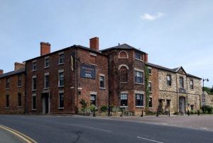
Turn left onto Bridge Street, passing the Roundhouse (1), an early 18th-century jail. Turn left onto Church Street at the Wynnstay Arms (2), an old coaching house.
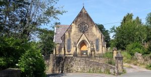
Go past the 13th century St Mary’s Church (LL14 6DS) (3). You must notify the curate in advance if you wish to look inside.
Soon, you will pass the Old Grammar School on your left and the almshouses on your right.
Turn right just over the railway bridge and follow the footpath along the edge of the cemetery. Cow parsley and rosebay willowherb grow here in abundance. There is an excellent view to your right of houses built from the famous local red brick. You can also see a clay pit away to your left.
Turn left, following the cemetery boundary. Look northeast, and, on a clear day, you can see the Peckforton Hills and Beeston Castle in the distance. Continue STRAIGHT AHEAD into the following field with the hedge on your RIGHT.
Tatham Farm
You are now on what was probably an original track from the hill fort, which you will see later. Follow the same line along a muddy lane to Tatham Farm (LL14 6RF). Go quietly through the farmyard, passing the recent barn conversions. Reach the road and turn right. The route now runs downhill and is adjacent to Offa’s Dyke, which is the bank on your right.
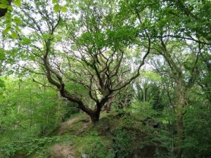
There are some majestic old oak, beech and sycamore trees here. You will also pass a “Ruabon Heritage Trail” information board.
Turn left just before the Industrial Estate into a lane. As you follow the steep uphill path, you may notice the great variety of plant life. Herb-robert, ramsons, hart’s tongue fern, foxglove and woody nightshade abound here. There are also holly, horse chestnut and elder trees.
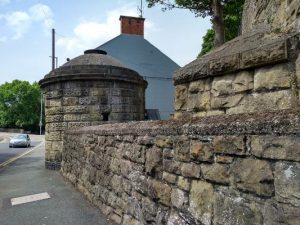
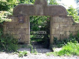
Ice House and Gardden Lodge
Follow the bend round to the right past the chalet-type house. A little further on, you can see the Ice House (4) on the left and, on the opposite side of the road, the site of Gardden Lodge (5). Up around the bend and past Pen-y-Coed, the remains of the prehistoric Hillfort (8) come into view. Here, there is a second board for the “Ruabon Heritage Trail”. The board contains some interesting natural and historical background information on the area.
There are some beautiful beech trees here as well as an abundance of birdlife. Extensive, picturesque views to the right reveal the now restored and landscaped Delph open-cast mine workings. Turn right by the semi-detached, Ruabon brick houses, go past the stone cottage, and the path leads you left into “Rocky Woods” (6).
You will come to a sandstone quarry on your right. From the point where it is closest to the path, count 80 average adult paces to a fork. The fork is at approximately SJ 29442 44531 – useful if you have a GPS.
Devil’s Bridge
Take the path on the right and, after 25 paces, turn left down a slight slope (SJ 29424 44539). Keep going downhill to pass another quarry on the left. Here you find yourself on a narrow ridge, with a chain mesh fence to your left, between the quarry and the river valley. Once nearing the bottom, continue in the same direction to find a broad cart track and waymarker.
Turn left and then take the right fork a few metres later to reach the famous “Devil’s Bridge” crossing the Afon Eitha. The bridge was a notorious spot for suicides in the 18th century. The wood is rich with plant life: bluebells, ramsons, yellow archangels, and oak, beech and rowan trees, to name but a few.
Go over the bridge and follow the path to the right up the hill. Turn right onto the B5097. Across the road, notice the clinker in the wall. There was a foundry nearby and the “clinker” or slag is the waste from the furnace.
Wynn Hall and “Brooklyn”
Continue past Wynn Hall, and just after the house called “Brooklyn” (a large white building), turn right onto a footpath that leads almost immediately to a gate and stile. Once over the stile, the trail then descends gradually to a footbridge.
Go over the footbridge and follow the obvious path diagonally right across the field. Reach the top of the embankment and head straight on. You will pass a way to your right. Cross over a culvert and pass through a few trees into an open field.
Descend to the hedge on your right, which you should then follow. This grassy bank is unimproved meadowland – a sanctuary for wildflowers, including vetch, sweet vernal grass, field woodrush and birdsfoot trefoil. Head for the large beech tree in the bottom corner of the field. Once you hop over the stile, you are back in Rocky Woods (6).
The Great Western
Follow the main track through the woods. You’ll soon rejoin the path you previously walked on to reach Devil’s Bridge. This time, continue past the bridge along the track, passing the red brick cottages to the road. Diagonally across to the right, you’ll see six steps up the roadside embankment. Go up these and through the kissing gate. Walk along the top of the steep bank, near to the hedge. The curious ridges in this field are a result of landslip, a common feature of clay soils on steep slopes.
Step over the stile on the other side of this field and follow the path. Walk along the boardwalk into some trees to reach the road. Turn right. Take the lane to the left of the Great Western public house signposted for the station and follow it to the footbridge across the river. The waterfall is host to a variety of plant life. Look out for sycamore, willow and rowan trees, and, in the spring, ramsons, bluebell and cow parsley.
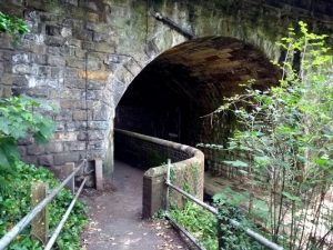
Go under the railway bridge (7) and follow the path back to Station Road.
Please report any problems to rightsofway@wrexham.gov.uk or 01978 292 057.
FOLLOW THE COUNTRYSIDE CODE
RESPECT – PROTECT – ENJOY
Be safe – plan ahead and follow any signs. Leave gates and property as you find them. Protect plants and animals and take your litter home. Keep dogs under close control. Consider other people.
Many thanks to Wrexham County Borough Council for supplying us with this walk. Please visit wrexham.gov.uk for more ‘self-guided walks’.
We hope you enjoyed “A Walk Around Ruabon, Gardden Woods and Hillfort“. For more of our features on local walks, please click here.
All photos courtesy of Rita Marchant.
