
Although long stretches of the Worthenbury walk are along country lanes, you will also cross grassy meadows with some great views of the surrounding countryside. You should encounter plenty of interesting birds like buzzards and pheasants.
Overview
I scouted the walk in early December after the wettest few weeks I can remember in my 10-plus years of living in Wrexham. The fields were waterlogged and resembled bogs in many places. I also encountered patches of standing water by some of the stiles that were easily six inches deep.
These pools were too big to be simply stepped over when approaching the stile. Therefore, I ended up having to ground my foot in the middle of the pool before stepping onto or off the stile, which meant the water was above my ankle, and I ended up with soaking wet socks and boots. If you wish to avoid such an experience, I recommend waiting for a period of dryer weather before setting out on the walk.
Starting Point
I parked in the middle of Worthenbury and headed east past Threapwood towards Cuddington Green before heading back west along a slightly more southerly route.
The walk is quite flat for the most part, with a total ascent of only just over 230 feet. The highest point is just over 205 feet – quite a difference from last month’s 1,220 feet. The map is available online at explore.osmaps.com/route/19544643 if you have an OS Map subscription.
Overview
The walk is reasonably dog-friendly, although you do pass through fields with sheep. You might have to lift a dog over some of the stiles. It is just over 6½ miles long and should take about 3 hours. You must read and understand the disclaimer on our website before attempting any of our walks: love-wrexham.com/ walk-disclaimer.
Pre-Walk Instructions
You can reach the village of Worthenbury by taking the B5069 from Bangor On Dee or Malpas. I parked on the main street, although The Community Centre near the church (LL13 0AW; What3Words: reseller.stuffing.nanny) also has a car park. You can, of course, park anywhere along the route if you know of somewhere.
Walk Directions
The easiest way to start off is by using the most prominent landmark, which is the church. Stand with your back to it, turn right up Church Road, and pass the Community Hall on your left.
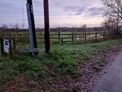
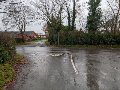
You’ll join the B5069 after a few yards and walk up the short high street. You’ll see the road soon bends to the left as it takes you out of the village. Leave the road at the bend and carry straight on along Mulsford Lane (1).
Wicket Gate
Ignore the stile on your left and instead turn left onto the drive about 100 yards further on (2).
Follow the drive round to the right and go through the metal wicket or walkers’ gate on your left. Head right across the field following the trodden path in the grass and hop over the stile after about 50 yards. Walk over the short wooden bridge and head straight on along the grassy track between the two barbed wire fences and areas of silver birch (3).
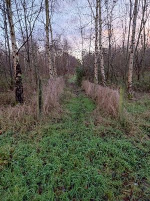
The silver birches give way to densely mixed bushes and hedgerows before reappearing again just before you cross the stile at the end of the track. Cross another short wooden bridge. Head straight on towards the cream-coloured house a short distance ahead of you. Cross the stile after a few minutes in the gap in the hedge ahead of you. Frog Lane Walk between the two thickets of trees and then bear left. You’ll see a rusty old roller on your side of the garden fence of the cream-coloured house (4).
roller!
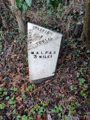
Cross over the drive and walk to the left of the picket fence so you walk round it with it on your right. Walk along the vehicle track with the grassy middle strip. You’ll come out onto Frog Lane or the B5069. Turn right and walk along the road for just over half a mile. There’s pavement most of the way, but there is a stretch without, so take care on that. You’ll pass Threapwood Post Office on your right and then a white house on your left. As the road straightens out, you’ll pass a mile marker (5), a 40 mph speed sign and a public footpath sign on your right.
Makeshift Metal Gate
Hop over the stile shortly afterwards by the public footpath on your left. Walk up the short slope onto the main part of the field. Walk straight on towards the other end of the field. Exit the field through the makeshift metal gate about 25 yards to the left of the telegraph pole. You’ll find yourself in a small grassed area with an electric fence in front of you. Look ahead to just beyond the oak tree and to the right of a short metal fence.
You’ll see an insulated handle you can detach from the fence and allow you to step over the bottom strand. Cross the drive and hop over the wooden stile. Carry on in the same direction so you’re walking along the field. You’ll walk past a small wood to your right.
Groves of Trees
When the wooded area ends, detach the black insulated handle to the right of a second electric fence and squeeze through the gap in the wooden poles. Walk to the left of the first thicket of trees and go through the gap in another electric fence by slipping between the wooden poles next to the left-hand edge of the copse.
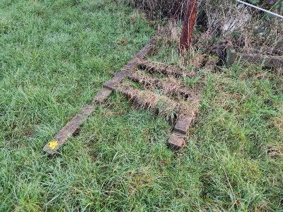
The gap is to the right of the old tree stump sticking out of the ground. You’ll see an old public footpath gateway lying on the ground (6).
Walk through the line of trees that runs across you. Walk to the right of the second grove of trees and slip through the gap in the poles of another electric fence. Exit the field through the hedgerow beyond using the two-stiled short wooden bridge.
Solitary Oak Tree
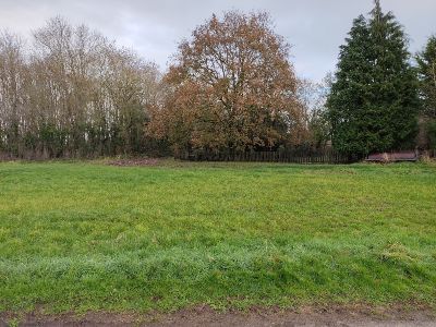
Walk straight across the field and exit over the wooden stile. Walk across the next field on a slight right diagonal (make sure you keep the solitary oak tree to your left) or northeast. You’ll step over a blue plastic pipe running across the middle of the field. Take the stile to the right of the decrepit metal cattle gate. In the next field, carry on in the same direction.
You’ll walk to the right of a pond with bullrushes and a small solitary tree (possibly an alder?). Hug the hedgeline to your right for about three to four minutes. You’ll see another short double-stiled wooden bridge which you use to exit the field. Keep your eyes peeled as the bridge/stile is easy to miss.
Purser Lane
Continue across the next field in the same direction until you reach a bridge/stile in the far hedgeline to the left of a metal cattle gate, which you use to exit the field onto Purser Lane (you’ll now walk along country roads for about a mile and a half). Turn right and carry straight on when you reach the junction onto Soughans Lane. Turn right again onto an unnamed road after about 0.3 of a mile. Follow the road round to the right after a few minutes, ignoring the left turn. Turn right after about half a mile and right again onto the B5069 after about 0.3 of a mile.
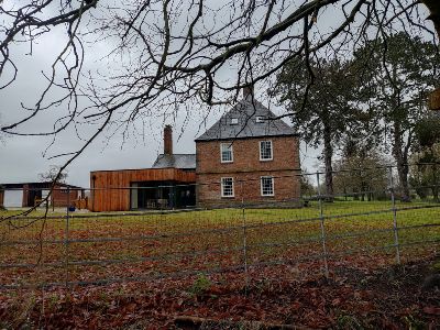
Take the next left after a little less than a quarter of a mile onto Tinkwood Lane. Go down the lane past the rather impressive red brick house on the left (7) and over the brook.
Walk between the two houses at the end of the lane and down the slope.
Flennan’s Brook
The slope can get slippery, so take care with your descent. Cross Flennan’s Brook using the concrete bridge with the metal gate at either end and turn sharp right. Hop over the stile and make your way up the slope to the metal kissing gate. Walk across the field, keeping the barbed wire fence to your left.
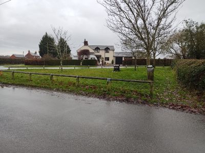
Cross the stile and walk down the narrow, grassy track until you reach the gravel drive. Turn left up the gravel drive with the cream-coloured house on your right and the white house on your left. Cross the first lane (where Oldcastle Lane meets Dog Lane) road and the small green (8), and then turn right onto Sandy Lane.
Back Lane
Sandy Lane is only 0.3 miles long, and you’ll walk past a house on the right called One Acre. At the end, turn right onto Back Lane and then almost immediately left onto Boundary Lane (it’s marked as Boundary Lane on Google Maps, but the road signs say it’s still Back Lane).
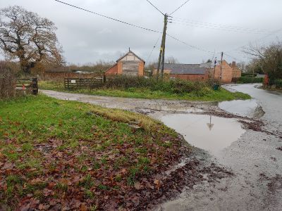
You’ll come to a T-junction with a drive directly in front of you across the main road, signposted “Middlewood Farm”. Walk down the drive (9) and go through the right-hand gate.
Walk to the right of the corrugated metal outbuildings and past VW Camper Haus on your right.
Mulsford Lane
Pass the front of a light green/ grey corrugated metal building. Carry on along the limestone chipping path with hedgerow on either side (10).
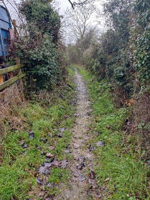
This grassy track twists and turns for about 0.75 miles. You’ll eventually come out onto Mulsford Lane – the same lane you started the walk on. Walk along the lane for about half a mile before reaching the centre of Worthenbury again!
Congratulations! You have completed the walk! If you’d like to see some more of our walks, click here.
