
This month’s walk takes you west and then north of Chirk Castle. It is relatively steep in parts and you will climb nearly 1,450 feet.
Walk Overview
The highest point of the walk is just over 1,200 feet, which, to put into context, compares with Dinas Bran (which you can see on the walk) at just over 1,000 feet.
OS Map ref: explore.osmaps.com/route/17791748 (subscription needed to see “Premium Topo” version. You can also use this version of the map.
You will have to walk over quite stony and uneven paths at times so a pair of stout boots is recommended. Some fields have patches of grass that are about knee-high, and you may want to wear gaiters or long trousers.
The walk is not really dog-friendly as you pass through several fields with cows and sheep. You might have to lift a dog over some of the stiles. It is about 7½ miles and will take you around three hours.
Disclaimer
You must read, understand and accept the disclaimer on our website before attempting any of our walks: love-wrexham.com/walk-disclaimer.
Walk Directions
Chirk Castle Car Park
Start the walk by going through the wooden gate in the top left hand corner of Chirk Castle car park. Turn right and go through three more gates as you walk up the fields about 300 yards to the two houses on the lane. Go through the green metal kissing gate to the right of the first house you come to. Turn left and follow the lane past the second house (1).
Turn left and go through the green metal kissing gate on your left. Walk up the stony path in the field, following the indicator arrow on the wooden post. The next indicator directs you left, but you should carry straight on. Make your way over the brow of the hill, through the gap in the fence and down the other side. Go through the green kissing gate and turn right along the stony woodland path. You will heading in a westerly direction.
The Ceiriog Valley
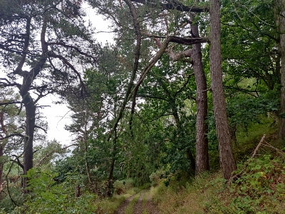
Look down into the Ceiriog Valley on your left for some great views. The path starts to rise, and you’ll come to a fork after a few minutes. Take the left fork (the lower one) – you’ll know you’re on the right path because you’ll have to dodge an overhanging pine branch after a few yards (2).
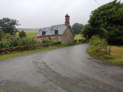
Follow the path downhill until you reach a T-junction. Turn right and walk past the cottage called “3 Garth Obrey”. Continue along the stone path until you reach a tarmacked road after a couple of minutes. Turn left.
Wonky Stile (Or Not)
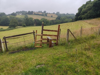
The road drops and you’ll walk past a house with an apiary called Dyffryn on your right. You’ll see a footpath sign on your right just past the house. Hop over the stile, go through the gap in the fence ahead of you (to the left of a stile), and then head diagonally left across the path trodden into the field until you reach a wonky-looking wooden stile (3). Its strange angle makes sense as you get closer! Hop over and head west across the field, keeping the large wood to your right.
Exit the field through the gap in the right-hand corner. You’ll see the chimney pots on a red-tiled roof dead ahead. Go through the metal cattle gate and turn right along the stony path. Pass Tŷ Nant cottage on your left and across the front of the old stone barn with the corrugated metal roof.
“Close the Gate”
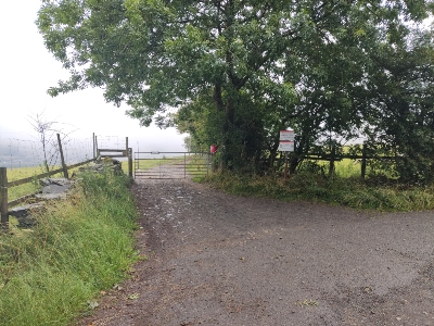
Carry on along the path, ignoring the steepish grassy track heading off right after a few minutes. There’s a stream running along the small valley down to your left. Go through the two metal gates with the red “Close The Gate” signs. Turn left when you reach the tarmacked lane at the top of the path.
Walk between the lovely white house – Plas Pennant – and the farm buildings with the geese and hens (4). Stop and admire the incongruous bell tower (Capel Pennant) on your left.

Continue along the road, ignoring the left turn to Pontfadog. Walk along the lane for about 20 minutes or approximately one mile until you reach a T-junction with a lone stone shelter with a corrugated iron roof. Turn right, continuing in the same general direction. Walk another half a mile and turn right at the road junction. You’ll find yourself on a dead straight road. Turn left after a minute or so and go through the gate with a red bucket on the right-hand gate post (5). Take the right-hand gate after a minute or so.
Dinas Bran
Walk along the path for about a mile. You’ll have amazing views to your left of the Vale of Llangollen, including Llangollen itself, the wooded hill of Pen-y- Coed, and Dinas Bran. The path then passes through Ty’n Celyn Wood before you reach a short wooden waymarker post on your right (6).

here
Turn right here and follow the path in an easterly direction for just over a mile. You’ll probably encounter a lot of sheep along this stretch! Go through the gate and take the lane ahead of you (7). Walk straight over the mini crossroads after about two to three minutes.

Turn left at the T-junction (8) after about 0.8 of a mile (~15 minutes). You’ll see Chirk Castle to your right through gaps in the hedge. After about three minutes, you’ll come to the cottages you saw when you walked up the hill from the car park.
Retrace your steps down the hill until you reach the car park.
Congratulations! You have finished the walk! If you’d like to see some more of our walks, click here.

