
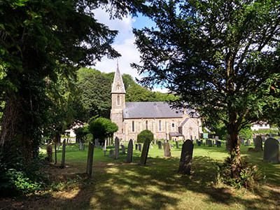
This month’s walk is along the west side of the Ceiriog valley from Chirk to Llanarmon. It covers approximately 12 miles, has a height gain of about 320 feet and should take around seven hours.
Ordnance Survey Explorer Map 255 covers the area, but the extracts available at the Wrexham Government website should be all you need for the walk.
This is a very complicated walk so we advise using a compass and GPS guidance.
Other maps of the walk are available from most local hotels and the tourist information points at the Post Offices in Chirk (Colliers Road), Pontfadog and Glyn Ceiriog.
The Ceiriog Valley Walk is the flagship walk of the Chirk and Ceiriog Valley Partnership devised 15 years ago to link all the villages in the valley from Chirk to Llanarmon (and vice-versa), with convenient access available by public transport to different sections of the walk. With excellent waymarking and facilities along the route, this is a ‘must-do’ for all types of walkers.
Public transport: Call Traveline Cymru on 0800 464 0000, text 84268 or visit traveline.info.
Disclaimer
Our walks follow public footpaths as indicated on OS maps wherever possible.
You must read, understand and accept our disclaimer before you attempt any of our walks.
Stage 1 – Under the Aqueduct: Chirk Main Car Park to Pont Faen
(1 mile; height gain: 65 feet; 30 minutes)
Leave the car park and turn left onto the main street. Continue past the church and start down the hill. About 75 yards after leaving the last building in town, cross the stile on your left. Follow the grassy track down to the right and bear left towards the old mill building.
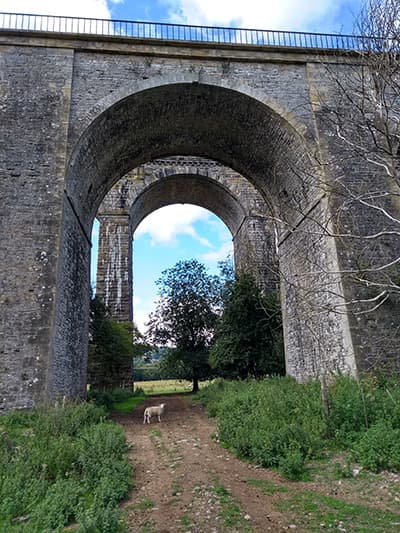
Cross the footbridge over the old mill race, go over the stile and carry on to a metal gate. Go through a gap to the left of the gate, cross the road carefully and pass through the kissing gate opposite. Continue along the track following the riverbank. Pass under the massive aqueduct and viaduct. Keep to the riverbank on your left until you come to a stone bridge. Pass through the kissing gate to the right and onto Pont Faen (stone bridge). Cross the bridge into England!
Stage 2 – The English Bit: Pont Faen to Offa’s Dyke
(1.7 miles; height gain: 510 feet; 1 hour 5 minutes)
Bus stops at Pont Faen and Castle Mill
From the bridge, turn right onto a riverside lane (we have just joined a section of the Maelor Way). Just past the telephone box, go over the stile on the right and through a meadow with the river on your right. Take the next stile that leads into woods owned by the Woodland Trust. Follow the path along the riverbank, take the steps and turn left when you reach the bottom.
Back In Wales!
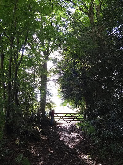
Carry on and cross a stile that takes you out of the wood, cross another one onto a track. Pass underneath the huge Black Poplar tree and follow the path to some double gates by a house. Continue up the lane to a road at the top. Turn right, walk a few yards and then fork left into a ‘green lane’ which runs down the left side of the old school building. Follow this short lane to its end and climb over a ‘hidden’ stile by the gate. Go through a gap in the hedge on your left and cut diagonally across a bumpy field. There is a quarry on your left. Go through an old hedge line into a small field and take the stile onto a stone track. Go uphill for five minutes until you reach a crossroads. Turn right and continue uphill for another 8-10 minutes until the track levels out. Magnificent views and a fine stand of beech trees and views of the castle across the valley are the reward for your climb. Arrive at a cutting through the 1,200-year-old Offa’s Dyke. You are back in Wales!
Footsore? You can take the Dyke Path downhill and then go down a steep lane down to the bus route at Castle Mill.
Stage 3 – Terraced lanes and pastures: Offa’s Dyke to Pontfadog
(2.2 miles; height gain: 214 feet; 1 hour 5 minutes)
Just 30 metres beyond Offa’s Dyke, as the track widens, take a stile by a gate on the right onto a level track. Continue along the track as it descends to two gates and a stile. Take the stile on the right into a field and drop down for 45 yards. Climb another stile by a gate. Go straight on, initially with a fence on your left. Keep going straight as the fence bends away. Walk past a boulder for about 220 yards, then gradually swing right and downhill to a stile near the corner of the field.
Go straight on, passing some hawthorn trees. Take the gentle ascent before dropping to reach the left-hand corner of the field. Cross the stile and descend quite steeply, keeping parallel to the hedge on the right. Go through the gap ahead of you and then left to a gate which opens onto a tarmac drive.
Follow the drive for two minutes to a lane with a large Nissen hut opposite. Follow this lane uphill ignoring all the turns and forks to the left. After 45 minutes on the lane, which starts to descend in stages, take the river bridge into Pontfadog village.
Stage 4 – Meadow and Woodland: Pontfadog to Glyn Ceiriog
(2.5 miles, height gain: 250 feet; 1 hours 30 minutes)
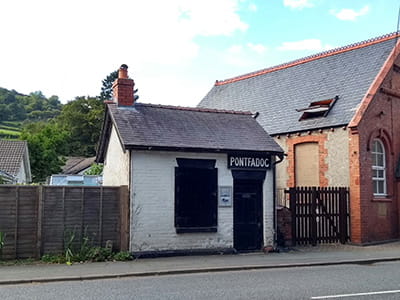
Facilities in Pontfadog include a post office/general store, bus stop, telephone box, old tramway waiting room, a garage and the Swan Inn.
From the centre of Pontfadog, follow the main road towards Glyn Ceiriog for about six minutes until you reach a crossroads. Turn right onto a minor road which rises steadily for three or four minutes. As the road finishes, turn sharp left onto a footpath above a garden and continue along it for approximately 440 yards until you reach a broader track. Turn left off this track to reach a tarmacked lane, turn right and walk for 15 yards until you reach an ‘arrow-head’ crossroads.
Go straight on and pass a letterbox on this initially-level lane. Continue for about six minutes until you reach the 30MPH restriction signs. Carry on for a further 65 yards to the crest of a rise and turn right between houses up a short green lane heading to a stile. Cross the stile, carry straight on uphill and then diagonally left through mixed woodland to a gate and stile into an open meadow.
Continued…
Follow the little depression uphill where a further stile leads to a path between hedges. Just 40 yards up this path, take the stile on the left into a meadow. Follow the level ground above the hedge-line for 110 yards and cross the stile and steps on the left. Continue along the same hedge-line, but now below it and cross another stile.
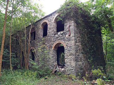
Keep generally ahead, but drop slightly away from the hedgerow, aiming to pass below a small group of Scots Pine trees and cross the stile. Pass between some derelict buildings and onto a tarmacked lane. Turn left downhill for 1½ minutes as far as a hairpin bend. Leave the lane here by going down a drive ahead of you that runs just above a house. Pass through a small gate, then head diagonally right and down below a stable block to a stream, footbridge and stile.
Go 50 yards downhill as far as the hedge, turn right and walk above the hedge and a large house, then turn diagonally left to a stile onto a tarmac lane. Turn right and walk along the lane for eight minutes, take the left junction around the edge of the school-playing fields to reach the main road opposite the school entrance. Cross over and find a riverside footpath and follow this for eight minutes until you reach Glyn Ceiriog Post Office. Go right uphill for a short distance to end this section at ‘The Cross’.
Stage 5 – The Pandy Hump: Glyn Ceiriog to Pandy
(1.5 miles; height gain 500 ft: 55 minutes)
Facilities in Glyn Ceiriog include bus stops, a post office, shops, The Institute, two pubs and a Christian Centre café.
This section goes over the magnificent ‘Pandy Rock’ which dominates the valley and will make you breathe heavily. Alternatively, you can walk along the valley road and save yourself over 20 minutes! You will miss out on wonderful views though and the road has no pavement so take special care.
If you do take the road option, follow the B4500 from The Cross towards Llanarmon for about 20 minutes. Shortly after the entrance to the caravan park, turn left through a gate onto the National Trust tramway track which takes you into Pandy after about five minutes.
To follow the recommended route, head south out of Glyn Ceiriog along the B5400. Take the right fork onto Nantyr Road after about five minutes. Continue along this road until you reach a hairpin bend – leave the road here and carry straight on along a rough track past a wooden cottage. Continue up this steep path for about 11 minutes until you reach the gate to a field. Go through the gate and go straight on – there’s a farm on your right-hand side.
Continued…
The path can be very muddy here and you may wish to skirt to the left to avoid some of it. Remember to keep the old hedge, which runs from the farm up the hill, on your right-hand side. After about four minutes, cross a stone track and continue up the ridge, again with the same hedge on your right-hand side.
After another five minutes of walking gently uphill, the land levels out. You have reached the highest point of the whole walk so take time to appreciate the extensive view! Here look for the ‘green lane’ which forks off to the left and follow this downhill with a fence on your left. Stick closely to the fence rather than the track and as the fence ends turn left, follow an old green ‘avenue’ down the field. At its end, turn right, follow a similar ‘avenue’ down to and through a field gate and continue for a couple of minutes until coming to two field gates on your left.
Go through the wooden gate and drop down onto the low green lane, passing to the right of an old hedgerow and past a derelict building. There is a field gate on the right, pass through this and continue down to the conifer wood. Turn right and follow the fence down the hill and cross a stile at the bottom. Turn sharp left without crossing the stream and follow this forestry track downhill for five minutes. At the tarmac lane, go approximately 440 yards left to reach Pandy.
Stage 6 – The Quarry and Tramway: Pandy to Tregeiriog.
1.8 miles; height gain: 70 feet: 50 minutes.
Bus stops at Pandy, Pontricket and Tregeiriog. There is a glass studio at Pandy.
Carefully cross the main road and head for the telephone box. Walk down the lane past the row of houses on your right. Go through the gate at the end and turn right to join the National Trust Tramway track. Continue along this level path for about 10 minutes until you come to a lane which you cross directly to go through a gate by a house with the bell on it (once the Quarrymaster’s House).
Walk along the tramway, crossing a stile and, after one minute, follow the left-hand fork uphill. Continue along this track for about 12 minutes, passing the entrance to the disused (and dangerous) Hendre Quarry. Ignore all the turns to your left or right until you come to the attractive stone buildings of Hendre Farm.
Continued…
Go between the main house and outbuildings and follow the gravel track downhill. At the T-junction (turn right over the river and walk for six minutes if you need to reach a bus stop), turn left up the lane for a minute, then turn right through a field gate and then almost immediately hop over a stile to follow a level track below the hedge line. Continue for a couple of minutes and when the track bears left into the field above, carry straight on to a stile.
Follow the level grassy track for about three minutes until you reach a stream and cross a stile. Keep right and cross another stile. Keep right as far as another stile and keep the fence on your right for five minutes until you reach a tarmac lane. Follow the lane to your right, through the gate until you reach a crossroads after about eight minutes.
If you wish to go to the hamlet of Tregeiriog to catch the bus, turn right here over the river bridge and carry on for five minutes until you get to a telephone box and bus stop.
Stage 7 – The Pheasant Strut: Tregeiriog to Llanarmon DC
(1.6 miles; height gain:150 ft; 40 minutes)
There are bus stops and phone boxes at Tregeiriog and Llanarmon. Llanarmon has public toilets and refreshments aplenty at two excellent hotels!
Cross the lane (but not the river bridge) into a minor lane, pass the pumping station on your right. Go through the road gate ahead and continue for one minute before turning right through a gate into the field. Continue “along the contour” for four or five minutes to reach a gate near the bottom of the mixed wood.
Continued…
Go through the gate and follow the level track through the pheasant wood. About four minutes later, where the main track drops down through a field gate, continue ahead on a grassier track (just inside the wood) with the fence on your right.
After four minutes, leave the wood through another field gate and continue (through a lot of bracken) with the fence still on your right. Then after four minutes, go past the house called Ty’n y Fedw keeping it on your right-hand side. You will come to a slightly boggy area after about two minutes.
Go slightly right to cross a stream and a stile in the corner of the field. There may be a sign here saying “Path 1 Is Temporarily Closed”, but we can take another path through the gate on the left of the field. Go straight on up the field and cross the stile at the end of the field. Carry straight on and, as you crest the rise, you’ll soon see an isolated barn ahead. Pass through a gate on the left of this barn onto a level grassy track. In two minutes, a field gate opens onto a tarmac road.
Follow this road down for about five minutes into the village of Llanarmon, your journey’s end!
You may join the path at Tregeiriog by taking public transport to Tregeiriog crossroads. Follow the side road going downhill for four minutes as far as the river bridge.
The amazing photos are courtesy of John Marchant
