
The Clywedog Valley Trail runs from Minera Lead Mines and finishes at King’s Mill. It is an easy-to-follow waymarked path along the river, helping you enjoy this peaceful valley’s natural beauty and uncover its rich history.
Overview

The Clywedog Trail is approximately 5.5 miles from start to finish. You can also cover this in shorter sections. The trail contains several stiles and gates.
The walk’s final section, which you encounter after crossing Sontley Road towards Kings Mill, can be very muddy during winter or wet weather. An alternative is to finish the walk at Sontley Road.
Parking is available at Minera Lead Mines (LL11 3DU) and Nant Mill (LL11 3BT). There is also on-road parking at Bersham and King’s Mill.
For more information on the trail, go to wrexham.gov.uk/countryside, call 01978 763 140 or email countryparks@wrexham.gov.uk.
For information on local buses, contact Traveline Cymru on 08712 002 233.
There are references to map points throughout the following directions. These maps and a whole host of other helpful information about the walk are available here. To get the maps, click on the PDF links for Clywedog Valley Trail – West and Clywedog Valley Trail – East in the right-hand column of the webpage.
Disclaimer
Our walks follow public footpaths as indicated on OS maps wherever possible.
You must read, understand and accept our disclaimer before you attempt any of our walks.
Minera Lead Mines
Head up the path towards the mine workings from the main car park at Minera Lead Mines. At the top of this path, turn left down the hill towards the wooden gate (map points A and B).
Go through the wooden gate, head to the road and turn right. Follow the road for a short distance until you reach the next waymarker on the opposite side by farm buildings. Follow this track to the stile and, once over, head over two more stiles. The path between the fences is then easy to follow (map point C).
At the road, bear left across to the path, keeping the river on your left. You are now entering land owned by the Woodland Trust. Carry on across the meadow.
Deep Day Level
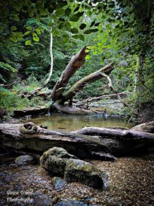
As you exit Nant Wood, the path splits: take the left way down some steps and cross the bridge over the river. Look out over “Deep Day Level” (map point D – Deep Day Level drained water from the mines upstream at Minera. The water is orange due to iron deposits in the rocks) emerging on your left. Follow the now-dry leete (leete means mill stream or water channel) and path towards Nant Mill playground (map point E).
Once at the playground, head across the car park and pass in front of the visitor centre. At the junction at the top of the road past the visitor centre, turn right and head down the short section of road. Just before the bridge (map point F), enter Plas Power Wood through a kissing gate on your left.
Offa’s Dyke and Caeau Weir
The trail meanders on a well-used path through the wood. As the river flows down the valley through Plas Power Wood, you will see parts of Offa’s Dyke (map point G) and Big Wood Weir (map point H). Towards the end of the woodland section, you will see the former leete (map point I) and Caeau Weir (map point J).
At the end of Plas Power Wood, join a road near the chapel. Turn left and walk along the road past the old ironworks foundry on your left (map points K and L).
Continue along the road towards the bridge carrying the main A483 overhead. Head under the bridge, turn left at the junction and then across the road towards the former Heritage Centre. Once at the centre, head down into the car park and go left past the playground. At the end of the grass area, go down the steps and at the bottom, turn left and then right along the road through Bersham village.
Felin Puleston
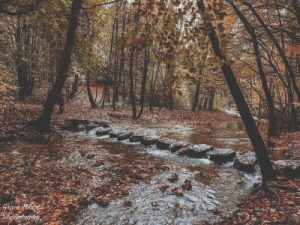
Once you have left the village, carry on along the track at the side of the river. Cross a bridge over the river and turn left over a stile. The path eventually opens up into a meadow (map points N and O). Keeping to the right-hand side of the field, head to the stile at the far end. Go over the stile and turn left up a track until you reach a footbridge.
After the bridge, turn right and take the right fork in the path. Follow the way through the field and over the footbridge. Carry on under the bridges and through a small wooded area. Climb the steep path to reach Felin Puleston (map point P).
The Erddig Estate
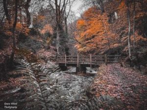
courtesy of Grace Wood Photography
Cross the footbridge just in front of the red-brick house. Go through the kissing gate on the right into Erddig Estate and follow the riverside path.
Carry on along the path through the first kissing gate. Go through the second one and head right. The track brings you to another pair of kissing gates on either side of a tarmac road.
Please note this section towards Kings Mill can be very muddy during the winter or in wet weather.
Coed y Glyn
Head through both kissing gates and go straight across the road. The path then meanders through Coed y Glyn (map point Q). When you reach the road, go through the gate. Head right and go through the kissing gate on the other side of the road. The path then carries on through woodland.
Ignore the first stile in the field and carry on until you reach the second. Go over this stile and turn left. Follow the edge of the woodland through the gap in the hedge (map point R).
Please note this section towards Kings Mill can be very muddy during the winter or in wet weather.
Once through the entrance, the field opens up – head across to the far right corner. Go through the kissing gate and across the field to the tunnel under the road, which takes you to Kings Mill and the end of the trail (map points S and T).
Congratulations! We hope you have enjoyed the Clywedog Trail and its fascinating history.
Please report any problems to rightsofway@wrexham.gov.uk or 01978 292 057.
FOLLOW THE COUNTRYSIDE CODE RESPECT – PROTECT – ENJOY
- Be safe – plan ahead and follow any signs
- Leave gates and property as you find them
- Protect plants and animals and take your litter home
- Keep dogs under close control
- Consider other people
Please report any problems to rightsofway@wrexham.gov.uk or telephone: 01978 292 057
We have taken the route from the council website. There is also a map available at that link.
Many thanks to Wrexham County Borough Council for supplying us with this walk. Please visit wrexham.gov.uk and look for ‘self-guided walks’.
We hope you enjoyed our article about “The Clywedog Valley Trail“. For more of our features on local walks, please click here.
