
Offa’s Dyke and Pentre-Bychan
Offa’s Dyke Pentre Bychan Walk: There is plenty to attract the walker all year round on this route because it is so rich in local history and wildlife. The walk is three miles long and takes you to Croesfoel, Cadwgan, Offa’s Dyke, Talwrn, Pentrebychan and Packsaddle.
Allow 1½ to 2 hours to complete the hike.
Parking: There is room for several cars at the entrance to the Crematorium (grid reference SJ 302, 480).
Public transport: Frequent bus services pass Croesfoel. Call Traveline Cymru on 0800 464 0000 or visit traveline.info.
Disclaimer
Our walks follow public footpaths as indicated on OS maps wherever possible.
You must read, understand and accept our disclaimer before you attempt any of our walks.
Pentre-Bychan Road
Start by heading south along Pentre-Bychan Road. Immediately after the two red brick houses, turn left at the kissing gate. Head diagonally across the field, aiming for a point between the offices on the right (partly hidden by trees), and the waterworks and Bersham Colliery spoil heap on the left in the distance.
You should arrive at a kissing gate and, a few metres further on, a gate leading to the road. Turn left, passing the Water Company’s premises and turn left again at the next road junction.
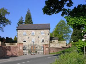
You will now be at Croesfoel (1). Read the plaque on the wall concerning the Davies family. Across the main road is the gateway of Hafod-y-bŵch (2), a beautifully renovated 15th-century house best seen from the by-pass. Take the signposted footpath that runs along the edge of a field by the hawthorn hedge, then almost immediately bear right through a gap in this hedge to head off diagonally, roughly parallel to the power lines.
Llyn Tro and Cadwgan Farm
Before reaching the tumulus or burial mound (the prominent hump in the field), take the stile in the hedge on your right. On the far side, cross a stile and take the path on the left leading to another stile before you reach the road. You can see the site of the moated house Llyn Tro (3) hidden amongst holly, willow and sycamore trees.
Retrace your steps and continue to the road. Turn left diagonally across it to a stile leading to a small field. Head across the field, following the stream (passing hazel, dog roses and lords and ladies) to another road. Take the stile opposite to pass alongside the cricket ground. Continue to the bottom corner of a field and cross another stile at the bottom of the disused railway embankment. Continue in the same direction to a lane.
Cadwgan Farm
Turn left and pass Cadwgan Farm (4) (postcode: LL14 4LH; what3words: flag.knees.allowable). This is now a modern ranch-style farmhouse, but the stone and brick outbuildings are ancient. A large, old sycamore stands above the stream and behind the farm, by the roadside, is a huge tumulus (5). Immediately after the tumulus, turn left over a stile onto Offa’s Dyke (6). There are plenty of flowers along here – depending on the time of year, you may see primrose, bluebell, foxglove, plantain, harebell and ragwort.
We hope you’re enjoying our article about “Offa’s Dyke Pentre Bychan Walk“. For more of our features on local walks, please click here.
Esclusham Farm
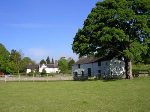
Pass through the old railway bridge abutments and follow the edge of the field. Turn right at the road. Just before the converted water grist mill, turn down the gated lane. At the bend, take the kissing-gate on the left and head towards another kissing-gate in the far corner. To the right is Esclusham Farm (7), a 17th century Grade II listed building with a framework constructed from ship’s timbers. There are also some attractive old stone and brick outbuildings. Cross the footbridge and walk up to another kissing gate. Turn left onto the road.
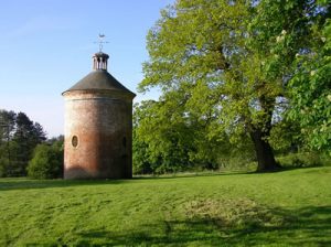
At the next road junction, turn left and go through the kissing gate on the right after 30 metres. There is a lovely place here to stop for a rest or picnic. Head across the meadow to the dovecote. This was part of the Pentrebychan Estate (8). The dovecote was rebuilt in 1721, and some of the oak trees may date from the same time.
The field abounds with white-flowered umbellifer with an edible tuber, pignut, and creeping and meadow buttercups – the latter is taller with more finely cut leaves.
Retrace your steps back to the road, turn left and head back to the Crematorium.
Places of Interest
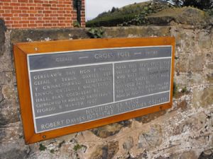
(1) Croesfoel or Groes Vael (Bare Cross) owes its name to a cross that used to stand nearby. The only reference to the cross dates from 1545. The original house Croesfoel was the most important building in the area, and the Jones family of Plas Cadwgan and the Roberts family of Hafod-y-bŵch live here.
(2) Hafod-y-Bŵch has been altered, but the rear of the house is original. In 1986, the owner won the Prince of Wales award for his restoration. The north wall of the west wing has a coat of arms dated 1590.
Llyn Tro Moat
(3) Llyn Tro Moat was 4-7 metres wide and 2 metres deep. A small stream, which later flows into Glanyrafon Brook, fed this, but now only a few stones and the partly filled-in moat remain.
(4) Cadwgan Hall (Plas Cadwgan) was the most significant estate in the manor of Esclusham. It has a fascinating past, which began when a great Welsh clan, who claimed to be descendants of Cynwig ap Rhiwallon, held the lands. The Great Hall, built in the 14th century, measured approximately 13 x 11 metres.
(5) Cadwgan Tumulus is a Bronze Age burial mound sited on Offa’s Dyke. In 1797, archaeologists excavated four sets of armour and the skeleton of a large horse. An alternative story states that a ‘cart-load of armour’ was excavated in 1804 and taken to Chirk Castle. There is a hollow on the north side of the tumulus indicating an excavation.

King Offa of Mercia
(6) King Offa of Mercia (757-796AD) constructed Offa’s Dyke. It marked a boundary between England and Wales and stretched for 130km (80 miles).
(7) Esclusham Farm was the home of the Trevor family for many generations.
(8) Pentrebychan was the principal estate of the area. Hugh Meredith acquired it in the 1620s. During World War II, it housed refugees and Denbighshire County Council purchased it in 1948. Sadly, it was demolished in 1963. The Crematorium now occupies the site.
We recommend you check that no exclusions are in place before you start. Visit ccw.gov.uk to check.
Maps
Click here to find downloadable maps, points of interest and other information related to this walk.
Please report any problems to Public Rights of Way, telephone 01978 292 000 or send an email.
Email your thoughts on this walk to the same email address or to Rights of Way, Abbey Road South, Wrexham Industrial Estate, Wrexham, LL13 9PW.
FOLLOW THE COUNTRYSIDE CODE RESPECT – PROTECT – ENJOY
- Be safe – plan ahead and follow any signs
- Leave gates and property as you find them
- Protect plants and animals and take your litter home
- Keep dogs under close control
- Consider other people
Many thanks to Wrexham County Borough Council for supplying us with this walk. Please visit wrexham.gov.uk and look for ‘self-guided walks’.
We hope you enjoyed our article about “Offa’s Dyke Pentre Bychan Walk“. For more of our features on local walks, please click here.
