
A Moorland Minera Walk: A ramble for experienced walkers only, much of it across moorland, starting from Coedpoeth.
The route described covers eight miles and has an ascent of 300m.
You will start and finish at Nant Mill and walk through Minera Lead Mines and over Minera Mountain.
Overview
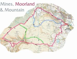
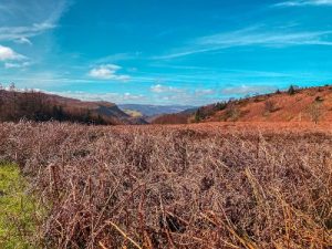
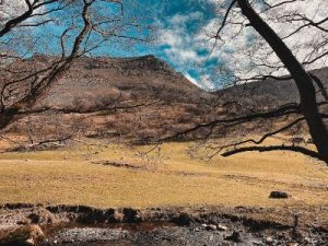
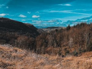
Specifically, the walk goes up the Clywedog Valley and onto the heather moorland above. There is a wealth of natural and historical interest on the walk. It can be cold and wet on the moor; it is always boggy. Check the weather forecast and take suitable footwear, waterproofs, torch, whistle, compass and food. Pack snacks and water for about three hours.
Maps: A 1:40,000 map should be sufficient (see the end of the article for how to download a map) when used with the walk directions. However, we recommend Ordnance Survey Explorer 256 for its greater clarity. A compass is essential.
We recommend you check that no exclusions are in place before you start. Visit ccw.gov.uk to check.
Disclaimer
Our walks follow public footpaths as indicated on OS maps wherever possible.
You must read, understand and accept our disclaimer before you attempt any of our walks.
Nant Mill Visitor Centre
You start at the Nant Mill Visitor Centre, Coedpoeth (grid reference SJ289501).
You can park at Nant Mill all year round. Follow signs the A483 and exit at junction 4. On the A525, head towards Coedpoeth and follow signs for “Nant Mill Visitor Centre”.
Alternatively, take the bus to Coedpoeth. Walk down Park Road and Nant Road to Nant Mill. Travel information: 01978 266 166.
Walk Directions
Distances are approximate so you can read yards for metres. Compass points are here for reassurance.
Follow the waymarked Clywedog Valley Trail to the lead mines as follows:
At Nant Mill, cross the footbridge by the ford and go up the lane. At the corner, take the riverside path ahead, a permissive way through Woodland Trust land. Opposite are the ruins of New Mills and the strong wall that carried Wilkinson’s Waggonway.
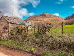
Beyond the descending steps, another riverside wall shows the bridging point. It then follows the path you are walking. Note the large rocks protecting the way at the river bend. Cross the lane, take the path opposite, and turn left at the end of the enclosed path. The waggonway used to be ahead here, but the ruined buildings are from a later date. Turn right at the road, then take the second left to the mines.
Hoffman Oval Kiln
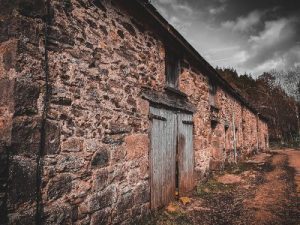
From the circular car park, go up the path behind the map display. Turn right onto the roadway and pass the engine house. Walk up the gravel patch and sweep left. Turn right along the dismantled railway for a mile, crossing three roads. At the buildings and a rectangular multi-entrance lime kiln, go straight on between the boulders and through the disused quarry. The enormous Hoffman oval kiln is hidden across the river through trees to your left.
Opposite the wooden footbridge on your left, fork right and leave the quarry by the gated tarmac road. At the brow, turn left by the last boulder. Beyond the stile, bear left, keeping the gully to the right and go up the green track. Go over the hill to the farm track corner.
Follow the stone track ahead through some buildings keeping the fence corner to your right. Go over the stile by the gate on the farm track. Follow the fence on the left. Cross the stile by the gate and onto the moor.
Follow the track by the wall. Where the wall turns left, continue ahead for 150 metres. Cross the stream and continue along the high bank.
Afon Sychnant
This is a former watercourse or “leete”. It is easier to walk on than the parallel footpath by the Afon Sychnant over the bank to your left.
In 600 metres, there is a sharp inland loop where you descend to cross a small stream.
Proceed 15 metres and look straight ahead to the far bank and a narrow path ascending it. This is where you are heading. Go another 100 metres along the leete, then cross the river. Head up the bank and go straight on as far as the spoil heaps at the mountain road. Turn left.
Leave the road after some 900 metres at the sharp bend to the left by the spoil heaps. Do not take the track on the right, but go straight on. Veer half left (30° E) on the narrow path and walk between the large spoil heaps. Go along the path, ignoring the right fork after 20 metres. Instead, fork left after 150 metres.
Cyrn-y-Brain
The path curves right (60° E) over the brow (behind you is the aerial on Cyrn-y-Brain and ahead of you, a lone tree on Minera Mountain).
Turn left to reach an open grassy plain passing large spoil heaps on your left.
Cross this in the same direction (due east, there are some turquoise roofs in the distance) to follow the path leading over the shoulder of the smallest hump (there is a lone tree 250 metres to the left) downhill half right, 500 metres to the stile by the gate below left.
Turn right, take the stile, turn left to the lane. Go downhill to the main road, turn right. Pass the chapel, path and phone box, and then turn left and down the drive to Hillside Farm.
The River Clywedog and Nant Mill
Carry on down the drive and walk straight on through three fields using the gates. Then take the path to River Clywedog. Cross the bridge slightly to the left and turn right to Nant Mill.
Maps
Click here to find downloadable maps, points of interest and other information related to this walk.
Please report any problems to Public Rights of Way, telephone 01978 292 000 or send an email.
Email your thoughts on this walk to the same email address or to Rights of Way, Abbey Road South, Wrexham Industrial Estate, Wrexham, LL13 9PW.
FOLLOW THE COUNTRYSIDE CODE RESPECT – PROTECT – ENJOY
- Be safe – plan ahead and follow any signs
- Leave gates and property as you find them
- Protect plants and animals and take your litter home
- Keep dogs under close control
- Consider other people
Many thanks to Wrexham County Borough Council for supplying us with this walk. Please visit wrexham.gov.uk and look for ‘self-guided walks’.
The beautiful photos are courtesy of Grace Wood Photography.
We hope you enjoyed our article about “A Moorland Minera Walk“. For more of our features on local walks, please click here.
