
This delightful four-mile walk over fields, along roads and through woodland should take you around two hours.
Overview
The route is straightforward and has plenty of variety and interest. It is predominantly flat with stiles and gates. The walk can be boggy and muddy in places, so we recommend a pair of good walking boots. You will have to walk through knee-high grass or crops, and gaiters or trousers may be prudent if it has been raining.
The starting point is St Mary’s Church in Whitewell (also known as Iscoyd). The church is a whitewashed brick building, formerly a “chapel of ease” (a more convenient place) for parishioners of Malpas in Cheshire.
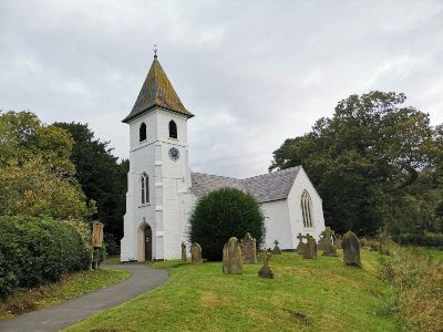
It is the only Welsh church in the Diocese of Chester. The present structure was built in the 1830s to replace an earlier timber-framed building, while the spire and clock date back to 1898. The two wells (in the name) are to the south of the church. Nearby is a large tumulus (twmpa), known as Waren Tump – it is probably a Bronze Age burial mound. A series of corn watermills used to stand along the Wych Valley, hence Llethr Mill and nearby Wolvesacre Mill. A war memorial opposite Iscoyd Park on Hall Green has seats for weary travellers.
There may be room to park near the church. Another parking place is by the road junction in Whitewell, just north of Broad Oak Farm. For public transport, please call Traveline Cymru on 0800 464 0000, text 84268 or visit traveline.info.
Click here to find the PDF map of the walk.
The total ascent is 230 feet (about 70 metres), with the highest point 242 feet or just over 73 metres.
Disclaimer
Our walks follow public footpaths as indicated on OS maps wherever possible. You must read, understand and accept our disclaimer before you attempt any of our walks.
Directions To Starting Point
Start: Whitewell Church SJ495414 (what3words reference: what3words.com/discouraged.sands.evolution
Whitewell Church
Go into Whitewell Churchyard (see front cover photograph) through the main entrance. Turn left after passing the cottage and go through the wicket gate in front of you (compass bearing: northwest).
Did you know the splendid old oak tree just next to the wicket gate out of the churchyard is listed by the Woodland Trust as being in the “veteran” category and has a girth of over six metres?
Skirt the field in front of you if the crops are high, following the hedgerow to the left or right (the public footpath actually runs straight across the field). Go through the opening in the middle of the far (northwest) edge of the field. Turn right and continue along the lane for about 150 yards. Turn left when you see a short wooden post with “Maelor Way” written on it.
Continue straight on along the edges of two fields until you spot a short dip between some trees on your left (after about a quarter of a mile). You should also see a way indicator. Make your way out of the dip and turn right as you enter the field. Walk along this edge with the wood and a fence on your right.
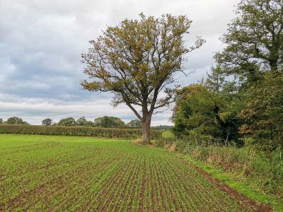
After about a quarter of a mile, you’ll see a large oak tree (1) in front of you. It’s standing alone and is peculiar because it has no branches around the lower part of its trunk. Go through the metal gate. It is also a “listed” tree
Kiln Green Barns
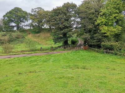
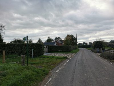
Continue with the wood on your right and go through the metal gate you come to after a few minutes. Walk down the bank diagonally to your right until you reach the cattle grid on the lane in front of you (2).
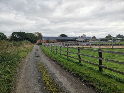
Turn right and walk up the lane (Kiln Green Lane). Go past the farm development buildings called Kiln Green Barns (3) on your right. When you reach the next set of farm buildings, it’s nearly time to turn right at the T-junction.
Walk a few yards and turn left into the field opposite Iscoyd Wellness Clinic (4). If you check your compass, you should be heading due east now. Cross four fields in pretty much a straight line. You’ll know you’re on the right track when you see a white wind turbine in the distance in front of you.
Llethr Mill
On the far side of the fourth field, you’ll notice an equestrian area in the left-hand corner as you look at it and a house to the left of it. This house is Llethr Mill and is a few yards up from the original mill. A leete fed this now dilapidated mill on the left and Wolvesacre Mill further down on the right-hand side of the lane.
Anecdotally, there is a stone here commemorating the spot where hunters killed the last wild wolf in Wales. Go through the gate just before the equestrian area and continue down the slope. You’ll see the stone dead ahead.
Continue straight onto the far side of the field and turn right along the lane.
So that you can find yourself on the map here, the what3words reference is what3words.com/error.jump.decisions.
Wych Brook marks the border between England and Wales and is no more than 100 yards to your left (or north).
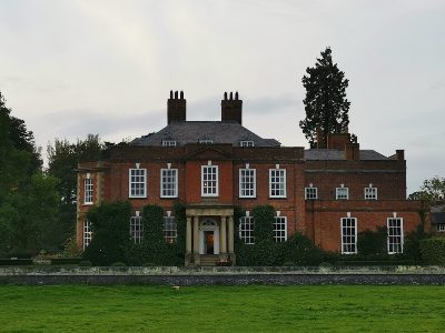
Iscoyd Park
Walk along the lane passing the recently constructed Wolvesacre Hall on your left. After about half a mile, turn left as the lane joins a road. Walk along the road, passing Iscoyd Park (5) on your left and the war memorial on your right.
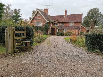
A few yards later, turn right onto Broomers Lane. Almost immediately, you’ll see a drive on your left signposted School Bank. Walk up here. The drive bears left at the top and opens out into a picture-postcard cottage, garden and outbuilding (6).
Go through the gate in front of you with the stables to your left. Pass diagonally left, go through the metal gate and down the hill. You’ll see a stile at the bottom of the slope. Hop over it and make your way across the first field. As you get closer to the hedge in front of you, you’ll notice a gap. Go through it and walk towards the solitary oak tree almost dead ahead.
Just beyond the tree is another gap in the woodland before you. Be careful descending the steep incline and cross the short bridge at the bottom of the dingle. Follow the path up the other side (it can get pretty boggy), ignoring the wooden in front of you at the top of the slope. Continue along the path as it bears right and then left. Go over the stile and continue straight on across the paddock until you reach the road (Whitewell Road).
Turn right and walk into Whitewell. Pass Stable House on your right and brick building (Parish Rooms) on your left. Very shortly afterwards, go through the ancient iron kissing gate on your right. Walk across the meadow towards the southerly aspect of Whitewell Church.
Cross the footbridge over the Iscoyd Brook and you’ve completed your loop!
We hope you enjoyed reading about our Iscoyd Walk. For more walk-related articles, click here.
